





Jet Streams — The Rivers of Air That Steer Britain's Weather
The jet stream that matters most to UK weather is a narrow ribbon of extremely fast-moving air, typically 7-9 miles (11-15km) up near the boundary between the troposphere and the stratosphere, where winds can exceed 200mph in the core. It exists because that's where two very different air masses meet — cold polar air to the north and warmer air to the south — and the sharper that temperature contrast, the faster the jet blows. Rather than a single fixed line, it behaves more like a river: fastest in a core stream, with progressively slower flow either side of it, and it meanders across the whole hemisphere in broad waves rather than following a straight path.
Why West to East?
The jet stream, like almost all of Britain's weather systems, moves from west to east. This comes down to the Earth's rotation and the fact that the equator is warmer than the poles: warm air rising at the equator and spreading poleward carries its eastward momentum with it, and as it moves over ground that's rotating more slowly (any point on the Earth's surface moves slower the closer it is to a pole), that air ends up moving progressively faster eastward relative to the ground beneath it, the further poleward it travels. Combined with the sharp temperature contrast at the polar boundary, the result is a fast, organised, eastward-flowing current rather than air spreading out evenly in every direction.

Surface rotation speed falls from over 1,000mph at the equator to zero at the poles. Air moving poleward keeps its faster eastward momentum, overtaking the ground beneath it — the Coriolis effect. Diagram: NOAA/NWS JetStream.
Two Jets, Not One
Europe sits under the influence of two separate jet streams. The polar front jet forms at the sharp temperature boundary between cold polar air and the milder air to its south — this is the one that steers the succession of Atlantic low-pressure systems across the UK, and it's the jet that matters for day-to-day British forecasting. The subtropical jet sits further south and higher up, formed where air descending from the tropical Hadley circulation is deflected into a fast eastward stream; it has more influence over Mediterranean and southern European weather than over the UK directly, though the two jets can merge or interact at times.
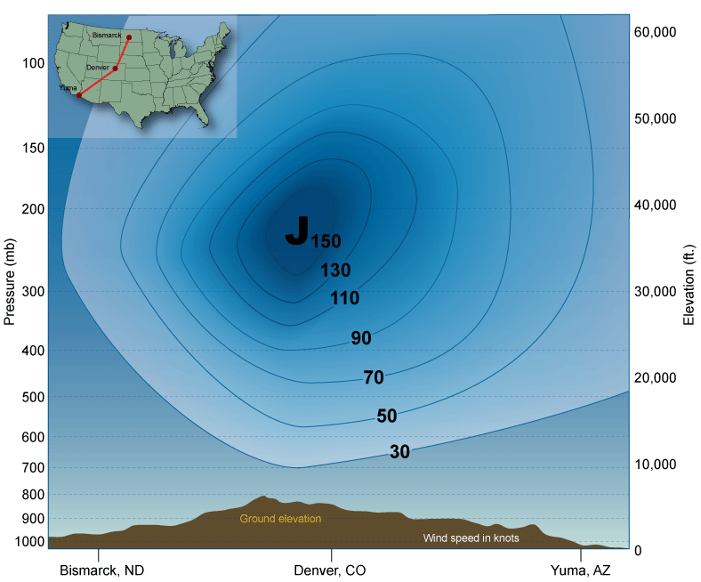

Diagrams: NOAA / National Weather Service JetStream — Online School for Weather.
Why the Jet Stream Decides Britain's Weather Pattern
Almost every prolonged UK weather pattern — whether it's a mild, wet, stormy spell or a cold, settled one — comes down to where the polar jet is sitting and how it's shaped. When the jet runs fairly straight and sits north of the UK, or directly over it, Atlantic low-pressure systems are steered straight across the country one after another in the "conveyor belt" pattern familiar from any particularly stormy British autumn or winter. When the jet buckles into a large, slow-moving wave — what meteorologists call a blocked pattern — it can dip a ridge of high pressure over or near the UK for days or weeks at a time, or swing far enough south to drag cold continental or Arctic air down over the country instead, which is the pattern behind cold snaps like the "Beast from the East". The jet's exact position and strength is also why the same low-pressure system can bring a wet, blustery week to Southampton while leaving Scotland almost untouched, or vice versa, depending on which side of the jet the country ends up on.
Other Jets and Wider Patterns
Away from the UK, several other, more localised jets exist: the African easterly jet over West Africa during the northern summer, which helps spin up the tropical waves that sometimes go on to become Atlantic hurricanes; the low-level nocturnal jet over the American Great Plains, which fuels overnight thunderstorm clusters; and barrier jets, which form where low-level wind is forced to run parallel to a mountain range rather than over it. On a longer timescale, the El Niño-Southern Oscillation (ENSO) in the tropical Pacific has a well-established, strong influence on North American jet stream position, and a real but considerably less direct influence over European winters — mainly by nudging the broader North Atlantic pressure pattern, rather than shifting the UK's jet stream in any simple, predictable way each time. Research covering 1979-2009 also found a slow poleward drift in the average jet stream position of a little over a mile per year in both hemispheres, which is one of the patterns climate scientists continue to monitor closely.
Follow It Live
Our Jet Stream Tracker page carries a live forecast chart showing the current position and strength of the jet stream, if you'd like to see today's pattern rather than just the general explanation above.