





Weather Fronts Explained
Most of the UK's day-to-day weather change comes not from the sun heating the ground differently, but from entire air masses — huge bodies of air hundreds of miles across that have picked up the temperature and moisture characteristics of wherever they came from — sliding past and over one another. A front is simply the boundary between two such air masses. Southampton sits directly in the path of the succession of fronts that the Atlantic jet stream steers across the UK for most of the year, which is the reason British weather has a reputation for changing so quickly: it isn't that the local weather is unstable, it's that a new air mass with a new front attached is arriving every few days.
Why Fronts Form
Warm and cold air don't mix readily — warm air is less dense and tends to slide up and over cold air rather than blend with it. Where a warm air mass and a cold air mass meet, that sloped boundary is the front, and it's along this boundary, where air is being forced to rise, that most frontal cloud and rain is generated. The four basic types below describe which air mass is advancing, which is retreating, and what that does to the boundary between them.

Cold Front
The leading edge of an advancing cold air mass, shown as a blue line with triangles pointing the way it's moving. Cold fronts undercut the warmer air ahead of them sharply, which forces it up fast — that's why cold fronts tend to bring a short, sharp band of heavy rain or showers, sometimes with thunder, followed by a noticeable temperature drop and clearer, fresher air behind.

Warm Front
The leading edge of an advancing warm air mass, shown as a red line with semicircles pointing the way it's moving. Warm air slides gradually up and over the retreating cold air ahead of it, producing a much shallower slope than a cold front — which is why warm fronts announce themselves hours in advance with high, thin cirrus cloud, thickening gradually to grey overcast and prolonged, steadier rain rather than a sudden downpour.

Occluded Front
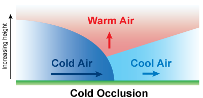
Cold fronts move faster than warm fronts, so a cold front often catches up with the warm front ahead of it, lifting the warm air between them clear off the ground. This combined boundary is the occluded front, shown as a purple line with alternating triangles and semicircles on the same side. It usually marks a weather system that has matured and is starting to weaken — the rain is often less intense than at either front on its own, but can still be prolonged.

Stationary Front
When neither air mass is advancing — the two are in a standoff — the boundary stalls in place as a stationary front, drawn as an alternating red/blue line with triangles and semicircles pointing to opposite sides. Because the front itself isn't moving through, the same cloudy, drizzly weather can sit over one area for days at a time rather than clearing through in the usual day-or-two a moving front takes.
Official map symbols: NOAA/NWS JetStream — Online School for Weather.
Why Cold and Warm Fronts Feel So Different
The symbols above show which way each front is moving, but the real difference between a cold front's short, sharp punch of weather and a warm front's long, grey build-up comes down to the shape of the boundary in cross section. A cold air mass is dense and hugs the ground, so an advancing cold front acts almost like a snowplough — it undercuts the warmer air ahead of it steeply, forcing that air up fast, which is why cold-frontal cloud and rain tends to be a narrow, intense band that clears through quickly. A warm front does the opposite job far more gently: the lighter warm air slides up and over the retreating cold air ahead of it on a much shallower slope, so the cloud and rain build gradually over many hours rather than arriving all at once.
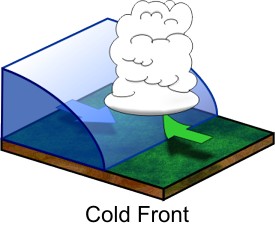
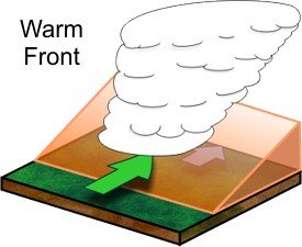
Diagrams: NOAA/NWS JetStream — Online School for Weather.
How an Occlusion Forms
Because cold fronts move faster than warm fronts, a cold front trailing behind a warm front eventually catches up with it. When it does, the cold air undercuts the cooler air mass that was already sitting ahead of the warm front, lifting the whole wedge of warm air caught between them clear off the ground — this is the occlusion process, and it's usually a sign that a weather system has reached full maturity and has started to weaken.
Fronts and Southampton's Weather
Almost all of the UK's Atlantic weather systems track from west to east, so a typical spell here starts with a warm front sliding through first — bringing the thickening cloud and steady rain — followed some hours or a day later by the attached cold front, which clears through more abruptly and often brings the heavier, shorter burst of rain along with a wind shift, usually backing from a southerly or south-westerly direction to a brisker westerly or north-westerly behind the front. Occluded fronts are the most common single type to cross Southampton, simply because most of the Atlantic lows reaching the UK have already matured by the time they arrive. Genuinely stationary fronts are less frequent here but do occur, usually when a spell of unsettled weather gets stuck, bringing several days of the same grey, drizzly conditions in a row before the pattern finally breaks down.