





Dew Point — The Most Honest Humidity Number
The dew point is the temperature air would need to be cooled to, at its current pressure, for it to become fully saturated and start condensing water out as dew. It's a genuinely useful number in a way that relative humidity, on its own, isn't — because relative humidity changes throughout the day just from the air warming and cooling, even if the actual amount of moisture in it never changes. The dew point tracks the moisture itself, so a steady dew point through the day means the airmass hasn't really changed, whatever the relative humidity reading is doing. When the dew point falls below freezing it's sometimes called the frost point instead, since the moisture deposits directly as frost or hoarfrost rather than condensing as liquid dew.

Dew Point, Temperature and Relative Humidity
The three are locked together: relative humidity is simply how close the current temperature is to the dew point, expressed as a percentage. When temperature and dew point are equal, relative humidity is 100% and the air is fully saturated — this is what produces dew on the ground, or fog if it happens right down at the surface. As air warms during the day with no extra moisture added, the gap between temperature and dew point widens and relative humidity falls, even though the air is exactly as "moist" as it was at dawn. That's why a muggy 8°C dew point at 6am can show 95% relative humidity, while the same dew point at 2pm on a 20°C afternoon shows barely 35% — nothing about the actual moisture content changed, only the temperature it's being measured against.
Why Pilots Watch It Closely
Dew point matters more to aviation than almost any other weather user. A small gap between air temperature and dew point is the classic signature of fog or low cloud forming, and pilots use the spread between the two to estimate cloud base height — as a rough rule of thumb, the cloud base in feet is about 400 times the temperature/dew point spread in °C. A close spread combined with humid air is also the classic setup for carburettor icing in piston aircraft, where moisture in the incoming air freezes inside the carburettor as fuel vaporises and cools it, even when the outside air temperature is well above freezing. This is one of the main reasons pilots taking a general aviation flight out of a local airfield check the dew point spread as carefully as the wind and cloud base before departure.
Same Dew Point, Different Altitude
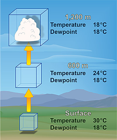
Dew point is a measure of how much water vapour is actually in the air, so comparing it between two places only tells you about moisture, not about anything altitude-related, unlike temperature which falls with height regardless of humidity. A given dew point reading represents a larger share of the total air mixture at higher altitude, since there's less air overall at reduced pressure to share the same amount of water vapour with — but for practical everyday purposes at a single location like Southampton, close to sea level, the dew point is simply a direct, pressure-stable read on how much moisture is in the air right now.
Dew Point and Southampton's Climate
Southampton's maritime setting keeps dew points fairly moderate most of the year. Winter dew points typically sit close to the air temperature itself — often within a degree or two — which is exactly the recipe for the valley and coastal fog that's common on still winter mornings here. Summer dew points more often run in the low-to-mid teens Celsius, occasionally pushing into the high teens during spells of humid tropical-maritime air arriving from the south-west, which is when the town feels properly muggy rather than just warm. Genuinely high dew points in the 20s Celsius, the kind that feel oppressive even at night, are rare in this part of the UK and tend to coincide with the same warm, humid, thundery spells that also bring the heaviest summer downpours.
How Dew Point Feels
Unlike temperature, dew point translates fairly consistently into a felt sense of mugginess regardless of the actual air temperature, because it's tracking how hard it is for sweat to evaporate off your skin. Meteorologists commonly use bands like these to describe how a given dew point will feel:
Approximate bands for people acclimatised to a temperate UK climate — those used to tropical humidity often find higher dew points comfortable.