Navigation
| High Temp |
| 16.0° C |
| London / Heathrow Airport |
| Low Temp |
| -4.9° C |
| Altnaharra |
| Precipitation |
| 65.6 mm |
| Ballypatrick Forest |
![]()
Site Updates
![]()
![]()
![]()
![]()
![]()
![]()


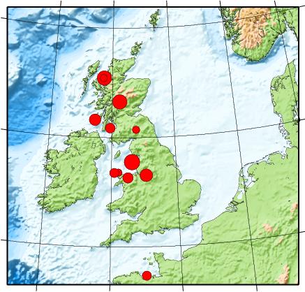
UK Earthquakes and Seismic Activity
The BGS Earthquake Seismology Team is the UK's national earthquake monitoring agency. They operate a network of sensors across the UK to monitor both British and overseas earthquakes, and provide objective information to government, industry and public.
They issue bulletins of earthquake activity and maintain an archive of seismological information and records. They use the data we collect to investigate the nature and distribution of earthquake activity and their driving forces, to improve understanding of earthquake hazard.
They also use the seismic waves from earthquakes to image the interior of the Earth and develop models of Earth structure.
| Earthquakes from around the British Isles recorded in the last 50 days | |||||||||
|---|---|---|---|---|---|---|---|---|---|
| Updated: 16/04/2025 21:37 | |||||||||
| Epicenter Near | Magnitude | Distance from Southampton | Local Time | Link to Map | |||||
| BAILRIGG,LANCASHIREE | 1.0 | 223 mi (358 km) | 16/04/2025 03:50 | Map | |||||
| ARDENCAPLE,ARGYLL/BUTE | 0.2 | 413 mi (664 km) | 09/04/2025 03:19 | Map | |||||
| SOUND OF JURA | 1.1 | 387 mi (622 km) | 08/04/2025 21:47 | Map | |||||
| LLWYNCROES,CARMARTH | 1.5 | 144 mi (232 km) | 08/04/2025 16:51 | Map | |||||
| BALINTYRE,PERTH/KINROSS | 0.8 | 411 mi (662 km) | 08/04/2025 16:02 | Map | |||||
| BALINTYRE,PERTH/KINROSS | 0.4 | 413 mi (664 km) | 08/04/2025 16:01 | Map | |||||
| MORECAMBE BAY | 1.0 | 234 mi (376 km) | 07/04/2025 16:34 | Map | |||||
| BALINTYRE,PERTH/KINROSS | 1.0 | 412 mi (663 km) | 07/04/2025 12:16 | Map | |||||
| BALINTYRE,PERTH/KINROSS | 0.6 | 412 mi (663 km) | 07/04/2025 12:14 | Map | |||||
| BALINTYRE,PERTH/KINROSS | 1.8 | 412 mi (663 km) | 07/04/2025 06:58 | Map | |||||
| ROSHVEN,HIGHLAND | 1.0 | 449 mi (723 km) | 04/04/2025 20:21 | Map | |||||
| BALINTYRE,PERTH/KINROSS | 1.7 | 412 mi (663 km) | 02/04/2025 23:55 | Map | |||||
| BRYNMAWR,GWENT | 1.0 | 102 mi (165 km) | 28/03/2025 15:34 | Map | |||||
| INNERLEITHEN,BORDERS | 1.4 | 333 mi (536 km) | 28/03/2025 07:54 | Map | |||||
| FOXFIELD,CUMBRIA | 0.8 | 243 mi (391 km) | 27/03/2025 08:59 | Map | |||||
| INVERGELDIE,P & K | 0.2 | 398 mi (640 km) | 27/03/2025 06:41 | Map | |||||
| IRISH SEA | 0.7 | 258 mi (416 km) | 26/03/2025 21:37 | Map | |||||
| CELTIC SEA | 1.4 | 192 mi (309 km) | 26/03/2025 04:19 | Map | |||||
| ARDNAMURCHAN,HIGHLAND | 1.0 | 443 mi (712 km) | 24/03/2025 03:47 | Map | |||||
| NETHERTON,NORTHUMB | 1.0 | 309 mi (497 km) | 23/03/2025 17:29 | Map | |||||
| WARRINGTON,CHESHIRE | 1.5 | 178 mi (286 km) | 18/03/2025 14:04 | Map | |||||
| KILNSEY,N YORKSHIRE | 2.0 | 222 mi (358 km) | 18/03/2025 07:37 | Map | |||||
| MULL,ARGYLL & BUTE | 1.3 | 418 mi (673 km) | 17/03/2025 19:16 | Map | |||||
| SOUTHERN NORTH SEA | 1.9 | 206 mi (331 km) | 14/03/2025 02:53 | Map | |||||
| BUTE,ARGYLL & BUTE | 0.5 | 373 mi (600 km) | 12/03/2025 23:05 | Map | |||||
| HINDERWELL,N YORKSHIRE | 1.0 | 253 mi (407 km) | 10/03/2025 03:50 | Map | |||||
| JERSEY,CHANNEL ISLANDS | 0.7 | 131 mi (211 km) | 09/03/2025 19:54 | Map | |||||
| IRISH SEA | 0.9 | 226 mi (363 km) | 01/03/2025 11:03 | Map | |||||
| KIPPEN,STIRLING | 0.7 | 380 mi (612 km) | 24/02/2025 16:17 | Map | |||||
| KIPPEN,STIRLING | 0.7 | 379 mi (611 km) | 23/02/2025 16:43 | Map | |||||
| KIPPEN,STIRLING | 0.2 | 380 mi (611 km) | 23/02/2025 16:43 | Map | |||||
| KIPPEN,STIRLING | 0.5 | 380 mi (611 km) | 22/02/2025 04:45 | Map | |||||
| RIDLEYWOOD,WREXHAM | 0.9 | 162 mi (260 km) | 22/02/2025 03:13 | Map | |||||
| RIDLEYWOOD,WREXHAM | 1.6 | 162 mi (261 km) | 22/02/2025 02:46 | Map | |||||
| KIPPEN,STIRLING | 0.9 | 380 mi (611 km) | 22/02/2025 00:24 | Map | |||||
| KIPPEN,STIRLING | 0.4 | 379 mi (611 km) | 21/02/2025 23:35 | Map | |||||
| KIPPEN,STIRLING | 1.2 | 379 mi (610 km) | 21/02/2025 21:57 | Map | |||||
| KIPPEN,STIRLING | 0.5 | 380 mi (612 km) | 21/02/2025 12:04 | Map | |||||
| KIPPEN,STIRLING | 0.3 | 379 mi (610 km) | 18/02/2025 22:50 | Map | |||||
| KIPPEN,STIRLING | 1.3 | 379 mi (610 km) | 18/02/2025 20:12 | Map | |||||
| KILMORE,ARGYLL & BUTE | 1.1 | 412 mi (663 km) | 15/02/2025 17:54 | Map | |||||
| LITTON,NORTH YORKSHIRE | 1.1 | 227 mi (366 km) | 15/02/2025 15:58 | Map | |||||
| LITTON,NORTH YORKSHIRE | 0.2 | 228 mi (366 km) | 15/02/2025 15:58 | Map | |||||
43 UK Earthquakes in the last 50 days.
British Geological Survey © NERC.
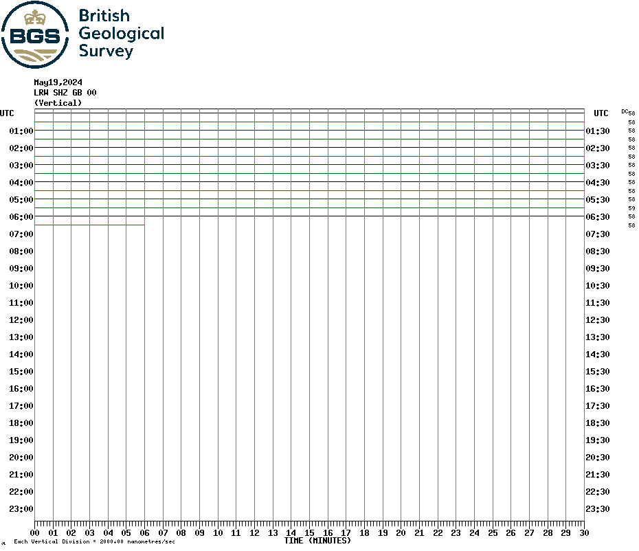
Today's Realtime Helicorder Output